
AEM
McLane Environmental routinely uses Analytical Element Method (AEM) models to develop and test conceptual models and to perform hydraulic analyses for a wide range of groundwater projects.
What is AEM?
AEM is a “new” way of groundwater modeling. It has been around for decades, but recent advances have brought it to the forefront of simple to use, but powerful, modeling techniques.
The AEM is a mathematical approach to solving groundwater flow model equations that results in exact solutions and does not require discretization of areas or volumes throughout the model domain. Analytical solutions for individual hydraulic features (well, river segment, infiltration basin) can be superimposed to obtain more complex solutions.
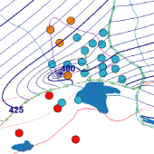
A collection of instructional materials, tutorials, tools, and training courses that provide extensive information on AEM and the latest tools and modeling techniques related to AEM can be found at www.flexAEM.com.
Why use AEM?
Because it is flexible, fast, and scalable.
AEM is a flexible, well-tested way to model hydrogeologic systems. It incorporates all key processes and features (multiple layers, aquifer anisotropy, transient simulations) and produces solutions that are identical to standard numerical codes such as MODFLOW.
The method can be easily used to develop simulations more quickly than conventional modeling techniques. Boundaries and hydraulic features can be drawn as simple polylines, and no grid setup is required.
In the cases where a more conventional model is needed, the AEM can be used to quickly compare differing conceptual models to determine the best modeling approach. AEM is the basis for the efficient “stepwise modeling” approach. Different conceptual models and computer model configurations can be quickly compared to determine the best modeling approach.
AEM Applications
- Heterogeneous Aquifers
- Anisotropic Aquifers
- Multi-Aquifer Systems
- Steady or Transient Conditions
- Fractured and Faulted Aquifers
- Saltwater Interface Modeling
- Cross-Sectional Modeling
- Soil Vapor Extraction Modeling
- Remediation Designs
- Construction Dewatering
- Capture Zone Analysis
- Mine Hydrology
- Aquifer Test Analysis
- Infiltration Bed Design
- Hundreds of other applications
McLane Environmental AEM Projects
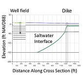
Sea Level Rise Impact to Public Supply Wellfield
AEM modeling of the saltwater interface was performed to investigate the risks posed to a coastal wellfield. The future location of the saltwater interface was determined under several likely sea-level rise scenarios with a range of projected well-field pumping rates. The modeling was used to better quantify the risks posed to public drinking water and assist the Town in evaluating future water supply alternatives.
Massachusetts Zone II Delineation and Environmental Impact Assessment
AEM modeling with AnAqSim was used to delineate the wellhead protection area (referred to as the Zone II area in Massachusetts) and determine changes in discharge to local surface water bodies. The model incorporated multiple aquifer layers, variable recharge from on-site septic systems, and perennial and intermittent streams. Developed in a step-wise approach, the same model was used for initial site conceptualization and iteratively refined to a well-calibrated transient model for the final Zone II delineation and environmental impact assessment.
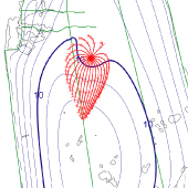
Superfund Site Contamination Pathways Analysis
AEM modeling was used to delineate pathways of groundwater flow and contaminant transport for a Superfund Site. Movement of the chlorinated volatile organic chemical plume was influenced by complex flow patterns in the vicinity of surface water features downgradient from the release point and by groundwater pumping from nearby water supply wells. The AEM model, which incorporated the geologic structure of the base of the shallow aquifer zone, accurately simulated the pathways of contaminant movement and the locations of contaminated groundwater to sensitive surface water ecosystems.
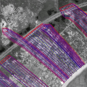
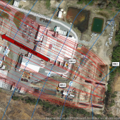
Wastewater Infiltration Bed Design and Permitting Study
Permitting of a municipal wastewater treatment system required the design of wastewater infiltration beds for daily subsurface disposal of hundreds of thousands of gallons of treated effluent. Groundwater mounding limits, and the proximity of sensitive pond and wetland areas, placed constraints on bed locations, surface areas, and loading rates. An AEM groundwater flow model was developed to support the project. With short run times, ease of model refinement, and high accuracy in the vicinity of critical areas, multiple design runs were completed in a relatively short period of time to support successful design and permitting of the wastewater disposal system.
Water Supply Impacts on Adjacent Surface Water Analysis
Siting studies for a proposed well field in a coastal aquifer setting required analyses of both the potential for saltwater intrusion and the delineation of a groundwater protection zone for the wellfield. An AEM model was constructed to rapidly perform both of these analyses, allowing changes to the model and wellfield configurations in far less time that would have been required for a three-dimensional freshwater and saltwater flow model. Preliminary results were later confirmed with longer simulations using a density flow model to support the final permit application.
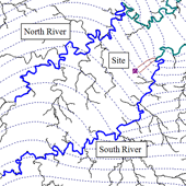
Manufacturing Site Release Pathway Analysis
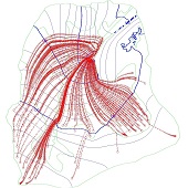
Detections of organic chemicals in water supply wells and surface water bodies had been potentially linked to releases of organic chemicals from a former landfill and from a number of former and active manufacturing facilities in the area. An AEM groundwater flow model with particle tracking was applied to provide a preliminary assessment of potential contributions from the identified sources. Groundwater flow patterns were strongly controlled by the patterns of nearby rivers, which were easily and accurately incorporated in the AEM model.
Agricultural Wastewater Permitting
Following a plant expansion to increase production, an agricultural processing facility required State permit approval for the resulting increase in subsurface wastewater infiltration. An AEM model was developed to calculate groundwater mounding beneath the wastewater disposal basins, and to outline the zones of treated water flowing away from the basins. Modeling results indicated that the current monitoring well locations met permit requirements under conditions of increased discharge, and the permit was successfully obtained.
Groundwater Flow Direction and CEA Development Study
To aid in the investigation of a dissolved VOC groundwater plume, AEM modeling was used to simulate the complex patterns of flow near a release site located in the vicinity of a groundwater divide. The model calculated the velocity and direction of groundwater flow both upgradient and downgradient from the site which aided in the investigation of potential off-site sources and provided the basis for establishing a CEA for the site using an analytical plume fate and transport model.
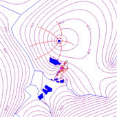
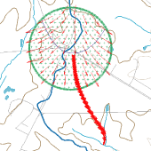
Quarry Hydrology Study
To support the planning of a quarry expansion project, geologic and hydrologic studies were performed to characterize the site. To aid in designing the proposed site aquifer test, an AEM model was developed to simulate the response of the fractured bedrock aquifer to pumping. The AEM model was used to examine optimal locations for the pumping well and monitoring wells relative to hydrologic features including a nearby stream, mapped geologic faults, and ongoing groundwater extraction in the area.